
Samtskhe-Javakheti, Georgia: Vardzia, Akhaltsikhe, and the Javakheti Plateau
Samtskhe-Javakheti is the largest region in Georgia — the country in the South Caucasus — by area, and one of the most varied in landscape, history, and cultural character. It occupies the southern tier of the country, stretching from the forested Borjomi gorge in the north to the high volcanic plateaus of the Javakheti highlands near the Armenian and Turkish borders in the south — about 200 kilometers that take in an extraordinary range of terrain, climate, and human history. The name reflects its two historically distinct halves: Samtskhe, the northern and western zone of medieval Georgian principalities, forested valleys, and the Mtkvari River corridor; and Javakheti, the high southern plateau of volcanic lakes, open grassland, and a predominantly Armenian-populated landscape that feels, in places, closer to the Armenian highlands than to the rest of Georgia. Together they make a region that rewards sustained exploration and tends to surprise travelers who arrive expecting a single character and find instead something genuinely layered.
What is Samtskhe-Javakheti known for?
Samtskhe-Javakheti is best known for the spectacular cave monastery of Vardzia, carved into a cliff above the Mtkvari and built under Queen Tamar in the 12th century; for the restored Rabati fortress in Akhaltsikhe, with its layered Georgian, Ottoman, and other heritage; and for the spa town and forests of Borjomi in the north. To the south, the Javakheti plateau offers a spare, high-altitude landscape of volcanic lakes — including Lake Paravani, the largest in Georgia — and important bird life. It also holds the ancient Khertvisi Fortress and the Sapara Monastery.
Historical background
The territory of Samtskhe-Javakheti has been inhabited and contested for an exceptionally long time. The Mtkvari valley corridor was one of the primary routes connecting Anatolia with the South Caucasus, and its strategic importance brought successive waves of settlement, conquest, and cultural exchange over several millennia. The pre-Christian Trialeti culture left remarkable Bronze Age remains in the northern parts of the region; the medieval Georgian principalities of Samtskhe, Javakheti, and Tao-Klarjeti developed here through the early medieval period; and the region served as the southwestern frontier of the unified Georgian kingdom during its Golden Age in the 12th and 13th centuries.
The medieval period left the most visible monuments. The cave monastery of Vardzia, the fortified town of Akhaltsikhe, and a network of smaller churches, monasteries, and fortifications across the valleys and ridges all date primarily from the 10th through 13th centuries, when the Georgian kingdom was at its most powerful and architecturally ambitious. The Mongol invasions of the 13th century ended this period, and the following centuries turned the region into a prolonged battleground between Georgian, Ottoman, and Persian interests. Ottoman control of the Samtskhe heartland lasted from the early 17th century until the Russo-Turkish War of 1828–29, when Russian forces captured Akhaltsikhe and absorbed the region into the empire. The Ottoman period left its own architectural legacy — most visibly in the mosque and the overall character of the Rabati complex in Akhaltsikhe — and significantly changed the region's demographics, as much of the Georgian Christian population was displaced or converted and replaced by Muslim populations from Anatolia and the wider Ottoman world.
Russian annexation in 1829 brought further change, including the settlement of Armenian communities from Anatolia and Persia on the Javakheti plateau and the invitation of German Lutheran colonists to the Borjomi and Akhaltsikhe areas. The Armenians of Javakheti, their community substantially reinforced by refugees from the 1915 massacres in eastern Anatolia, now form the majority population of the southern plateau districts. The German settlers were deported in 1941. Soviet rule reorganized the region's economy and left its architectural imprint on the towns, and post-independence Georgia has worked to reintegrate Javakheti — whose Armenian majority has at times raised grievances about economic development and language accommodation — into the national mainstream.
Vardzia
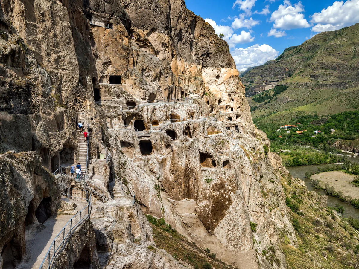
The cave monastery of Vardzia, carved into the cliffs of the Erusheti Mountain above the Mtkvari River about 70 kilometers south of Akhaltsikhe, is one of the most extraordinary historical monuments in Georgia and the wider Caucasus. Construction began under King George III in the 1150s and was substantially expanded under his daughter, Queen Tamar, in the late 12th century, reaching its greatest extent in the years around 1185–1205 when the Georgian kingdom was at the height of its power and cultural confidence.
At its peak the complex held roughly 3,000 rooms across thirteen stories of cliff face, including a principal cave church dedicated to the Dormition of the Virgin, a throne room, a pharmacy, a wine cellar, a system of irrigation channels that watered the cliff gardens, and living quarters for a monastic community that may have numbered several hundred. The whole was connected internally by tunnels cut through the rock, allowing movement through the settlement without exposure on the cliff face. A catastrophic earthquake in 1283 — striking just decades after the Mongol invasions had already weakened the kingdom that built Vardzia — collapsed the outer section of the cliff and exposed about two-thirds of the rooms to the open air, giving the site its characteristic honeycomb appearance of open cave mouths stacked across the cliff.
The earthquake that damaged the structure also, paradoxically, preserved much of what remained: the outer section fell away cleanly rather than crushing the interior, leaving the inner chambers intact with their original features. Several of the cave chapels retain their 12th-century fresco cycles in a state of preservation that is remarkable after eight centuries of exposure. The principal church holds frescoes of exceptional quality, including a portrait of Queen Tamar that is one of the oldest surviving representations of the queen who presided over Georgia's Golden Age. A small monastic community still lives and worships at Vardzia, maintaining a thread of religious continuity from the 12th-century foundation to the present.
The approach follows the Mtkvari gorge south from Akhaltsikhe through a landscape that grows more dramatic as the river cuts deeper into the volcanic rock. The cliff at Vardzia is visible from the road well before the entrance, and the scale of the excavation — the sheer number of cave openings across the full height and width of the exposed cliff — is one of those sights that photographs convey imperfectly and direct experience makes immediately clear.
Akhaltsikhe and Rabati
Akhaltsikhe, the regional capital with a city population of around 45,000, sits in the Potskhovi River valley at about 1,000 meters and has been the administrative center of Samtskhe since the medieval period. Its defining landmark is the Rabati fortress complex, occupying a large hilltop above the city and holding within its walls an unusual assembly of elements from different eras: a medieval Georgian citadel, an Ottoman-era mosque with a slender minaret, a Georgian Orthodox church, a caravanserai, and a synagogue — a mixture that reflects the successive layers of control and community that shaped the town. The complex underwent a major and controversial restoration, completed in 2012, that rebuilt and in places substantially reconstructed the structures within the walls. The result is visually impressive and well organized for visitors, but it has prompted real debate about the limits of historical restoration — the line between conserving what survives and rebuilding what was lost isn't always clearly maintained. That debate is itself part of what makes Rabati worth engaging with thoughtfully.
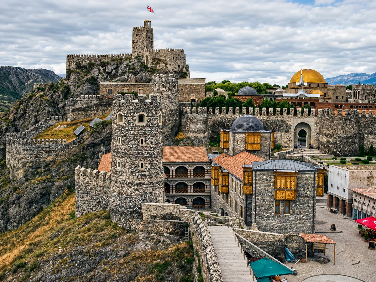
Akhaltsikhe is also the natural base for the wider region. Vardzia is about 70 kilometers south, and the Khertvisi Fortress — a medieval fortification of considerable antiquity above the confluence of the Mtkvari and Paravani rivers — lies roughly 40 kilometers along the same road. The Sapara Monastery, a 13th-century complex in a forested gorge 12 kilometers from Akhaltsikhe, preserves some of the finest medieval Georgian fresco painting in the region and combines easily with a visit to the town. (Akhaltsikhe has its own detailed guide in this series.)
Borjomi
Borjomi, at the northern end of the region where the Mtkvari enters through a deep forested gorge, has its own detailed guide. In the regional context, it's the most accessible and most visited entry point into Samtskhe-Javakheti from Tbilisi and central Georgia, and its character — a 19th-century imperial spa town in one of the most beautiful forested gorges in the country — is completely different from the historical and plateau landscapes to the south. The Borjomi-Kharagauli National Park, beginning at the edge of town, is one of the largest protected forest areas in the Caucasus and provides the region's most developed infrastructure for hiking and nature-based tourism.
The Javakheti plateau
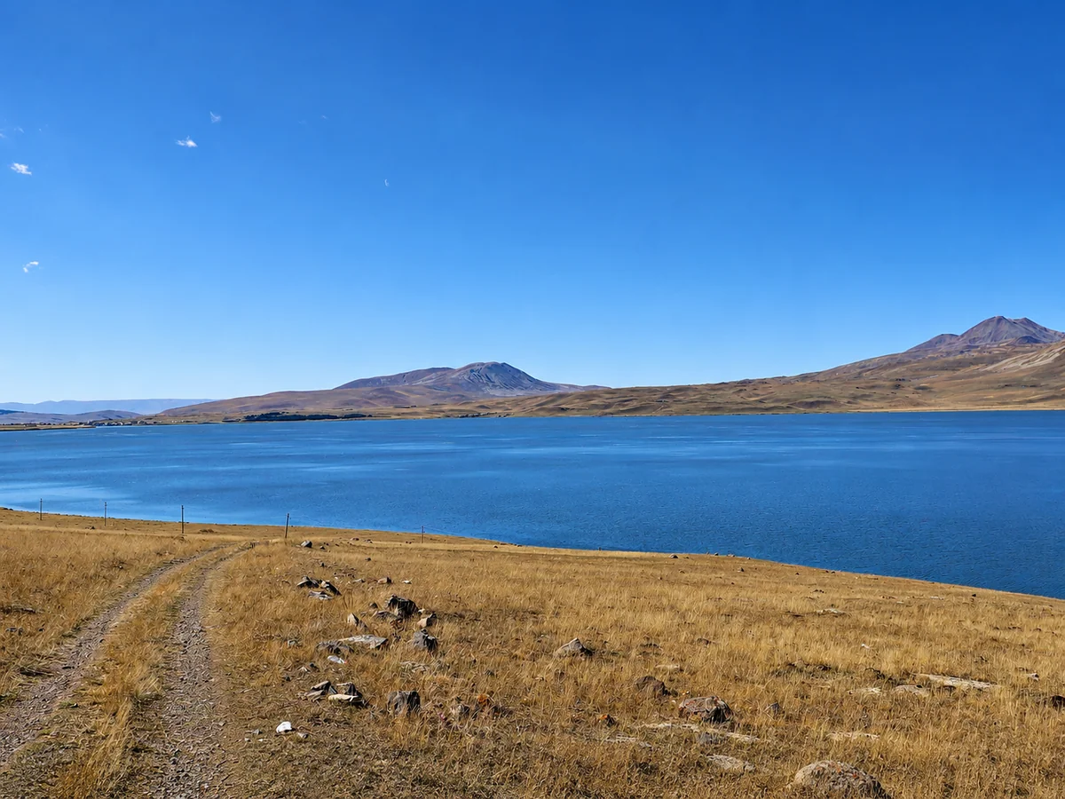
The southern part of the region — Javakheti proper — is physically and culturally distinct from Samtskhe to the north. The plateau rises to elevations between 1,700 and 2,500 meters, its surface a landscape of open volcanic grassland, basalt outcrops, and a series of large glacial and volcanic lakes whose still surfaces reflect the enormous skies above. The largest, Lake Paravani, covers about 37.5 square kilometers at around 2,073 meters — the largest lake in Georgia and one of the highest substantial water bodies in the South Caucasus. The plateau has a spare, wind-swept beauty unlike anything else in Georgia, and the sense of openness and elevation — the horizon extending in most directions across a landscape with almost no vertical interruption — startles visitors used to the country's typically enclosed mountain and valley scenery.
The towns of Akhalkalaki and Ninotsminda are the administrative centers of the Javakheti districts. Both are predominantly Armenian-speaking communities with their own distinct cultural life, and the churches, markets, and daily interactions give a picture of Georgian provincial life quite different from the ethnic-Georgian mainstream. Road connections have improved markedly in recent years — the main route from Akhaltsikhe to Akhalkalaki and on to the Armenian border at Bavra is now paved and reasonably maintained — but the plateau remains far less visited than the Samtskhe monuments, and travel here keeps a genuinely off-circuit quality.
The Javakheti highlands are also significant for their bird life. The lakes and wetlands of the plateau support important populations of migratory and breeding waterbirds, and the area has been identified as a significant zone for bird conservation in the South Caucasus. Pelicans, a range of waders, and other species use the plateau lakes during migration, and dedicated birdwatchers visit specifically for these during the spring and autumn passage.
Khertvisi and the Mtkvari gorge
The stretch of the Mtkvari valley between Akhaltsikhe and Vardzia, where the river cuts progressively deeper into the volcanic rock as it descends from the plateau, holds a series of historical sites along the gorge walls that together make the drive one of the more historically dense road journeys in Georgia. Khertvisi Fortress, at the confluence of the Mtkvari and Paravani rivers, is among the oldest fortifications in Georgia — origins are attributed to the 2nd century BC, with the present walls dating from the medieval period (the standing walls largely from the 14th century). The fortress occupies a triangular promontory where the two rivers meet, its walls dropping to the water on two sides and accessible only across a narrow neck from the plateau above — a site chosen with the strategic intelligence visible throughout the medieval Georgian tradition of fortification.
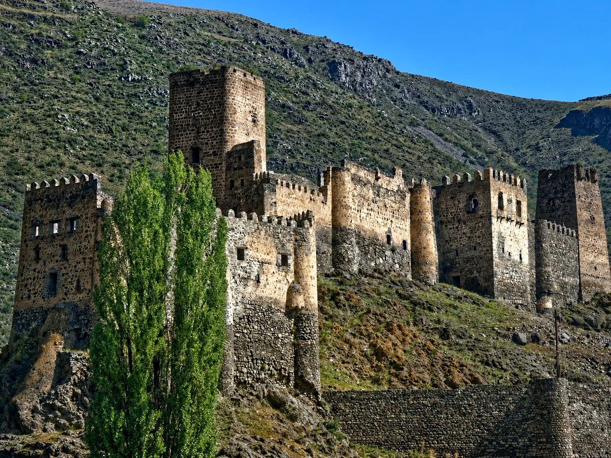
Between Khertvisi and Vardzia the gorge narrows and deepens, the road cut into the cliff above the river and the basalt walls rising on both sides. Scattered cave churches and hermit cells are visible in the cliff faces — smaller and less organized than Vardzia, but evidence of the same tradition of rock-cut religious life that ran through this whole river valley in the medieval period.
Getting there and around
The main entry to Samtskhe-Javakheti from Tbilisi is through Borjomi, reached by road in about two and a half to three hours. From Borjomi the road continues south through the Mtkvari valley to Akhaltsikhe, a further 50 kilometers and roughly 45 minutes. Marshrutkas run from Tbilisi to Akhaltsikhe via Borjomi with reasonable frequency, making public transport a viable way to reach the regional center. From Akhaltsikhe, onward travel to Vardzia, Khertvisi, and the Javakheti plateau needs a private car or taxi, as public-transport connections to the more remote sites are limited and infrequent. The road south from Akhaltsikhe to Vardzia follows the Mtkvari gorge and is paved and well maintained. The plateau roads to Akhalkalaki and Lake Paravani are paved on the main routes, but secondary roads across the plateau can be rough and require appropriate vehicles in poor weather. A car is strongly recommended for anyone covering the full range of the region's sites.
When to visit
The most comfortable and rewarding seasons are late spring through early autumn (May through October), though different parts of the region have quite different optimal windows. The Borjomi gorge and the Akhaltsikhe area are pleasant from April through October, spring especially so when the forests are fully green and the rivers running high. Vardzia and the Mtkvari gorge are accessible year-round but most comfortable from May through October — the exposed cliff and the approach road can be cold and icy in winter, though the site stays open. The Javakheti plateau has a short summer season: the high elevation means long, harsh winters, with snow from November through April and temperatures well below freezing, and even summer nights can be cold. The plateau is at its best from June through September, when the grasslands are green, the lakes fully ice-free, and the high-meadow wildflowers in bloom. Autumn (September into October) brings clear skies, lower temperatures, and the start of the migratory bird season on the lakes.
Caucasus Travel FAQ
It's the largest region in Georgia by area, in the south of the country, running from the Borjomi gorge to the high Javakheti plateau near the Armenian and Turkish borders. It's best known for the Vardzia cave monastery, the Rabati fortress in Akhaltsikhe, the spa town of Borjomi, and the volcanic lakes of the Javakheti highlands, including Lake Paravani, the largest in Georgia.
Vardzia is a 12th-century cave monastery carved into a cliff above the Mtkvari River, about 70 km south of Akhaltsikhe. Begun under King George III and expanded by Queen Tamar, it once held around 3,000 rooms across thirteen levels. A 1283 earthquake collapsed the cliff's outer face and exposed the caves, giving it its honeycomb look; its main church keeps a famous 12th-century portrait of Queen Tamar, and a small monastic community still lives there.
Yes. The hilltop complex layers a medieval Georgian citadel, an Ottoman mosque, a church, a caravanserai, and a synagogue — reflecting the town's mixed history. A major 2012 restoration rebuilt much of it; it's impressive and visitor-friendly, though the heavy reconstruction is debated among those who care about conservation. Akhaltsikhe also makes the best base for Vardzia, Khertvisi, and Sapara Monastery.
It's a high volcanic plateau (1,700–2,500 m) of open grassland and large lakes, including Lake Paravani, the largest in Georgia, at around 2,073 m. The landscape is spare, windswept, and unusually open for Georgia, with a predominantly Armenian population in towns like Akhalkalaki and Ninotsminda. It's an important area for migratory birds and remains well off the main tourist circuit.
The usual entry from Tbilisi is via Borjomi (about 2.5–3 hours by road), continuing south to Akhaltsikhe (another ~50 km). Marshrutkas run from Tbilisi to Akhaltsikhe via Borjomi, but reaching Vardzia, Khertvisi, and the Javakheti plateau needs a car or taxi, as public transport to the remoter sites is limited. The Akhaltsikhe–Vardzia road is paved and well maintained.