
Shida Kartli, Georgia: Uplistsikhe, Gori, and the Historic Heart
Shida Kartli — "Inner Kartli" — is the central region of Georgia, the country in the South Caucasus, occupying the broad valley of the Mtkvari River and its tributaries between Tbilisi to the east and the Surami range to the west, with the Greater Caucasus foothills rising to the north and the Trialeti and Likhi ranges marking the southern and western margins. It is the geographical and, in many ways, the historical heart of the country — the territory around which the Georgian kingdoms consolidated, fragmented, and reconsolidated across two millennia. For travelers, it rewards those who look beyond the obvious landmarks (and the obvious landmarks are significant enough) to a landscape that carries its history unusually close to the surface.
What is Shida Kartli known for?
Shida Kartli is best known as the cradle of the Georgian state — the heartland of the ancient Kingdom of Kartli (Iberia), with its first capital at Mtskheta. Its standout sites are Uplistsikhe, one of the oldest rock-hewn cities in the Caucasus; Gori, the regional capital and birthplace of Stalin; the early-medieval Ateni Sioni church in its quiet vineyard valley; and, just at its eastern edge, the UNESCO-listed monuments of Mtskheta. It's the most accessible region from Tbilisi and a rich day-trip or short-stay destination for history and architecture.
The region's administrative center is Gori, but Shida Kartli is best understood not as a set of towns but as a continuous historical landscape, in which settlements, fortifications, churches, cave cities, and ordinary farming villages exist in a density and variety that reflects the area's long role as the core of Georgian political life. The Mtkvari valley here is wide and fertile, the fields and orchards well tended, and the villages connected by roads through a countryside where the medieval and the contemporary coexist without much self-consciousness.
Historical significance
The Kartli region — of which Shida Kartli is the inner, central portion — is where the Georgian state first took coherent form. The Kingdom of Kartli, known in ancient sources as Iberia, was established here in the 4th century BC with its capital at Mtskheta, just north of modern Tbilisi at the confluence of the Mtkvari and Aragvi rivers. For the next millennium, the Kartli kings navigated the competing pressures of Persian, Roman, Byzantine, and later Arab power while maintaining a degree of continuity and developing the cultural and religious identity that would come to define Georgian civilization. Christianity was adopted as the state religion in 337 AD — earlier than almost anywhere in the world — and the early Christian monuments that followed are among the most significant in the South Caucasus.
The region's central position made it the primary target during invasions and the primary prize during reunifications. The Arab occupation of the 7th–9th centuries, the Seljuk devastation of the 11th, the Mongol invasions of the 13th, the Ottoman and Persian campaigns of the 16th and 17th — all passed through Shida Kartli and left their marks. The Georgian Golden Age of the 12th and early 13th centuries, when the unified kingdom under David the Builder and Queen Tamar reached its greatest extent, was anchored in this central valley, and the prosperity of that period is visible in the quality of the religious architecture that survives.
The 20th and 21st centuries added their own layers. Gori's identity as Stalin's birthplace brought a particular kind of Soviet attention, and the conflict of August 2008 — when Russian forces advanced down the Mtkvari valley to within striking distance of Tbilisi before withdrawing — gave the region's geopolitical sensitivity a contemporary dimension that residents feel acutely, particularly in the communities nearest the administrative boundary with South Ossetia (the Tskhinvali region). That part of Shida Kartli has remained outside Tbilisi's control since the early 1990s and occupied since 2008, and the boundary area continues to see periodic "borderization" — fencing and the shifting of the de facto line that has at times cut villagers off from their own farmland. It's a living part of the region's story, and a sensitive one.
Uplistsikhe
The most ancient and in some ways most remarkable site in Shida Kartli is Uplistsikhe, the rock-hewn city carved into sandstone cliffs above the north bank of the Mtkvari about 10 kilometers east of Gori. The settlement was established in the early Iron Age, around the first millennium BC, and served as one of the most important urban and religious centers in the region for well over a thousand years. The name translates as "fortress of the lord" — the lord being a pre-Christian deity rather than the Christian God — and the site's origins as a center of indigenous Georgian religious practice predate Christianity by many centuries.
The scale of what was carved here is genuinely impressive. The settlement spread across a large area of cliff face and plateau, with rooms, streets, tunnels, water channels, and specialized spaces cut directly into the living sandstone. Identifiable spaces include what appear to be apothecary rooms with carved stone shelving, a large ceremonial hall whose carved ceiling imitates the coffers of a timber roof in stone, storage chambers, wine-pressing facilities, and a network of connecting tunnels that allowed movement through the settlement away from the exposed streets. At the highest point, a 9th-century Christian basilica was built using stone salvaged from the earlier pre-Christian structures below — a physical layering of religious traditions that is one of the site's more eloquent details.
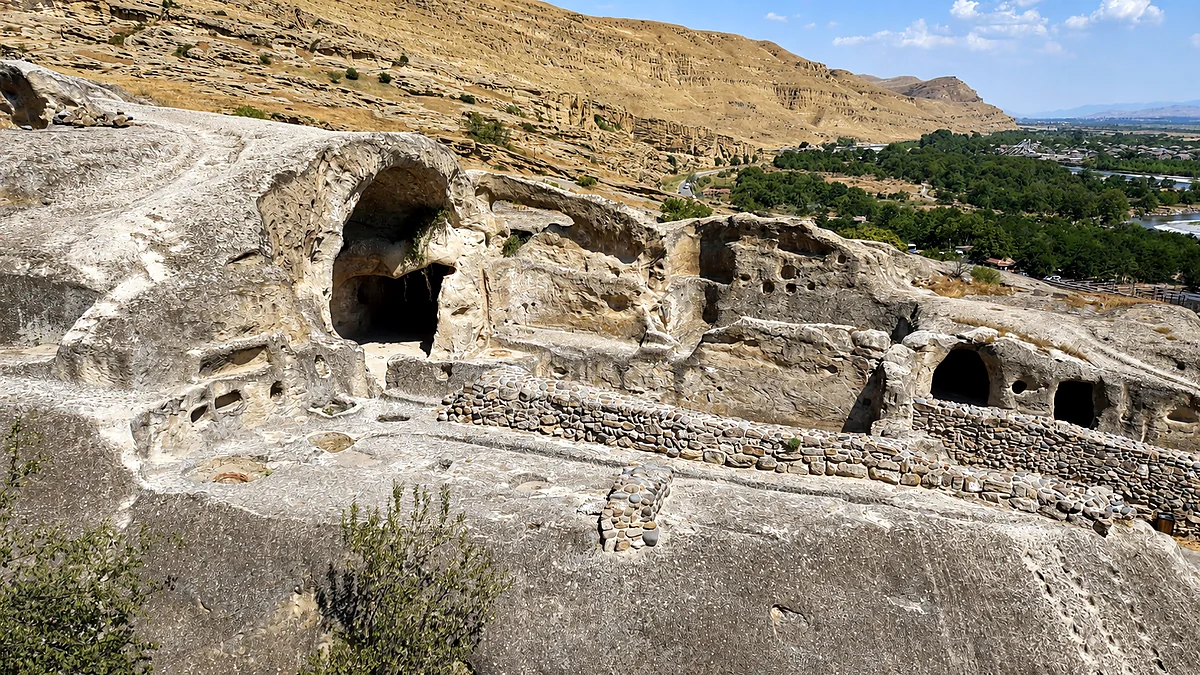
Uplistsikhe remained occupied and significant through the early medieval period, serving at times as a royal residence and administrative center. It was eventually abandoned in the later medieval period as the political center of gravity shifted definitively to Tbilisi, and left to the erosion and vegetation that have shaped what visitors see today. The sandstone preserves the carved forms with remarkable clarity, and walking the settlement — the worn paths between chambers, the tunnels that require ducking, the open plateaus with their views across the Mtkvari valley — gives a physical sense of early urban life that no museum display can match.
Gori
Gori, the regional capital with a city population of around 42,000, has its own detailed guide in this series. Within the regional picture, it's the logistical center of Shida Kartli and the natural base for visiting both Uplistsikhe to the east and the Ateni valley to the south. The medieval fortress, Gori Tsikhe, sits on the rocky volcanic hill that gives the city its name and offers the best elevated view over the Mtkvari valley and the plain. The Stalin Museum — whatever one makes of its curatorial approach — is the region's single most visited attraction and an unavoidable point of engagement with the 20th-century history that shaped so much of modern Georgia.
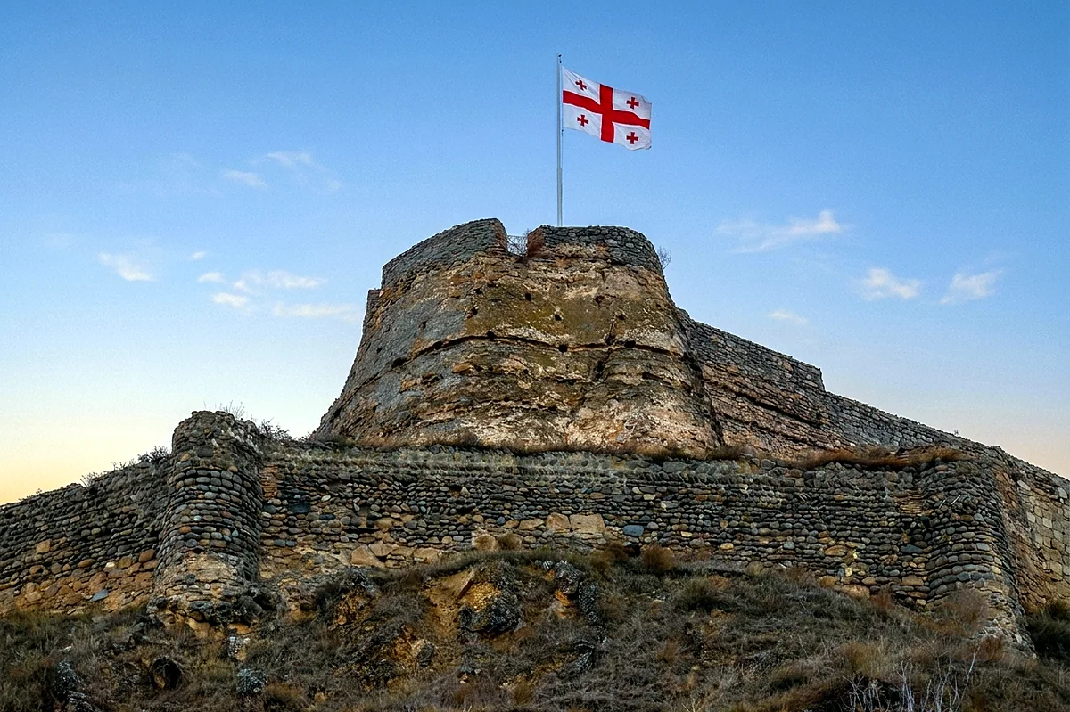
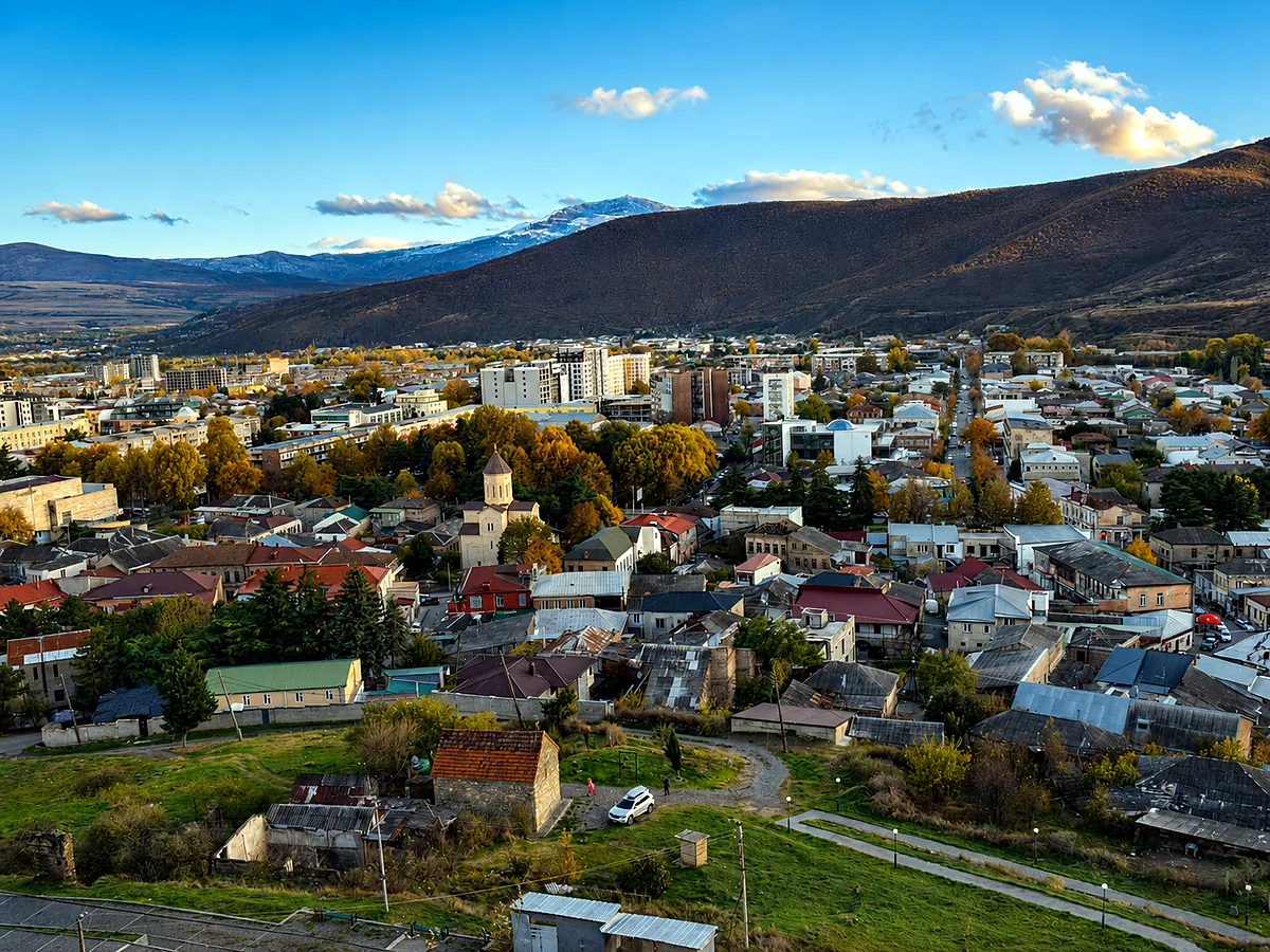
The city itself has a provincial character that is neither especially picturesque nor remarkable but is entirely real — the markets, residential streets, and small cafés and restaurants near the central square give a straightforward picture of daily life in a regional Georgian city that has seen more than its share of historical turbulence without becoming dramatic about it or wholly defined by it.
Ateni Sioni
About 12 kilometers south of Gori, in the narrow valley of the Tana River where it cuts through the hills above the Mtkvari, the Ateni Sioni Church stands in a setting of exceptional quietness and natural beauty. Built in the first half of the 7th century, it's one of the earlier surviving examples of the cross-in-square (tetraconch) plan that became the dominant form of Georgian ecclesiastical architecture through the medieval period. The exterior carries stone relief carvings and inscriptions of real quality, and the interior retains significant portions of its original fresco cycle, extended in the 11th century when Shida Kartli was part of the unified kingdom at its height.
The valley setting — vineyards and orchards on the lower slopes, the river below the church, forested hills rising steeply on both sides — is much of what makes Ateni Sioni one of the more rewarding religious sites in the region. It sits well off the main circuits and sees far fewer visitors than Mtskheta or the better-known Mtkvari valley monuments, which gives a visit an unhurried quality that suits the place. A ruined medieval fortress, Ateni Castle, overlooks the valley from the opposite hillside and can be reached on foot from the church, adding an architectural counterpoint to the monument below.
The villages of the Ateni valley are among the more traditionally agricultural in Shida Kartli, their character shaped by the vineyards on the slopes. The Ateni microclimate — sheltered, south-facing, with well-drained hillside soils — produces high-quality grapes, and local wine production, though small, has a long history here.
The landscape and agricultural character
Away from the specific monuments, the broader landscape of Shida Kartli rewards slow travel rather than itinerary-driven hopping between sites. The Mtkvari valley at this latitude is wide and productive, its floor shifting between grain fields, orchards, and vineyards depending on terrain and the families who work it. The villages are compact and functional, their architecture a mix of traditional Georgian forms and Soviet-era construction characteristic of rural central Georgia.
The Greater Caucasus foothills north of the valley are dotted with smaller settlements and connected by secondary roads that climb through increasingly dramatic terrain toward the Liakhvi and Prone river valleys. These northern districts bore the most direct consequences of the 2008 conflict and the displacement associated with the South Ossetian administrative zone, and the area still carries that recent history visibly — rebuilt communities, some abandoned settlements, and the markers of the boundary zone. Travelers should be aware that the immediate vicinity of the administrative boundary is sensitive and best approached with local guidance; the main valley sites (Uplistsikhe, Gori, Ateni) are well away from it.
Mtskheta
Although administered as a separate municipality, Mtskheta — the ancient capital of Kartli and one of the most important historical sites in Georgia — is geographically and historically inseparable from the Shida Kartli story. At the confluence of the Mtkvari and Aragvi 20 kilometers north of Tbilisi, at the eastern edge of the region, Mtskheta was the capital of the Kartlian kingdom for roughly a thousand years and retains a concentration of early medieval religious monuments — Svetitskhoveli Cathedral, the Jvari Monastery on its cliff above the confluence, and the Samtavro Monastery in the town — among the finest surviving examples of Georgian ecclesiastical architecture. The town and its monuments were designated a UNESCO World Heritage Site in 1994. Mtskheta has its own dedicated guide in this series, but its proximity to Gori and Uplistsikhe makes it a natural part of any Shida Kartli itinerary.
Getting there and around
Shida Kartli is the most accessible region in Georgia from Tbilisi. Gori lies about 85 kilometers west on the main highway, roughly an hour in normal traffic, and the road continues to Kutaisi and Batumi. Regular marshrutka and train services connect Gori to Tbilisi through the day. Uplistsikhe is most conveniently reached by taxi from Gori (around fifteen minutes), or by marshrutka along the Tbilisi road, alighting at the site turnoff. The Ateni valley needs a car or taxi from Gori and isn't served by regular public transport. A car gives the most flexibility for the secondary roads and smaller villages, particularly in the northern foothills and the Ateni and Tana valleys to the south.
When to visit
Shida Kartli is comfortable to visit year-round, and its proximity to Tbilisi makes it a strong day trip in any season. Spring (April–June) offers the most pleasant conditions for the outdoor sites — Uplistsikhe's plateau and the Ateni valley especially benefit from mild temperatures and the green of the surrounding farmland. Summer is warm and the valley fully productive, though the exposed sandstone of Uplistsikhe gets intensely hot at midday, so morning visits are better in July and August. Autumn brings harvest activity to the Ateni vineyards and clear weather that extends the comfortable season through October. Winter is mild at valley elevations, the major monuments stay accessible, and the reduced visitor numbers give the sites a welcome quiet.
Caucasus Travel FAQ
Shida Kartli ("Inner Kartli") is the central region of Georgia, in the Mtkvari valley between Tbilisi and the Surami range, with Gori as its capital. It's the historic heartland of the ancient Kingdom of Kartli (Iberia) and is known for the rock-hewn city of Uplistsikhe, Gori and its Stalin Museum, the Ateni Sioni church, and the nearby UNESCO monuments of Mtskheta.
Uplistsikhe is one of the oldest cities in the Caucasus, carved into sandstone cliffs above the Mtkvari River about 10 km east of Gori. Established around the first millennium BC, it was a major urban and religious center for over a thousand years, with rooms, streets, tunnels, and a ceremonial hall cut into the rock, plus a 9th-century church at its summit. The name means "fortress of the lord."
Yes — it's the most accessible region from Tbilisi. Gori is about 85 km (roughly an hour) west on the main highway, with frequent trains and marshrutkas, and Uplistsikhe is a short hop beyond. Many travelers combine Mtskheta, Gori, and Uplistsikhe in a single day, or add the quieter Ateni Sioni with a car.
Ateni Sioni is an early-medieval church about 12 km south of Gori, built in the first half of the 7th century in the cross-in-square plan, with fine stone carving and an interior fresco cycle. It stands in a beautiful, quiet vineyard valley with a ruined fortress on the hillside opposite — well off the main tourist circuits.
The main sites — Uplistsikhe, Gori, Ateni Sioni, Mtskheta — are well away from the administrative boundary and visited normally year-round. The immediate vicinity of the boundary with South Ossetia (the Tskhinvali region) is a sensitive area best approached only with local guidance; it isn't somewhere to wander independently.