
Mtskheta-Mtianeti, Georgia: Mtskheta, the Military Highway, and Kazbegi
Mtskheta-Mtianeti is the region directly north of Tbilisi, in Georgia — the country in the South Caucasus — stretching from the ancient capital at the confluence of the Mtkvari and Aragvi rivers to the high Caucasus peaks and the Russian border at the northern end of the Georgian Military Highway. For the range of experiences packed into a compact area, it's arguably the most complete region in Georgia: the country's most important religious and historical monuments, its most famous mountain road, its premier ski resort, and its most iconic mountain landscape all fall within one administrative boundary. For most visitors to Georgia, Mtskheta-Mtianeti isn't optional — it's where the journey through the country often begins, where the most fundamental questions about Georgian identity and history get their clearest physical expression, and where the transition from the lowland Caucasian world to the high mountains happens with a drama and speed that the Georgian Military Highway makes both inevitable and exhilarating.
What is Mtskheta-Mtianeti known for?
Mtskheta-Mtianeti is best known for Mtskheta, the ancient capital and spiritual heart of the Georgian Orthodox Church, with its UNESCO-listed Svetitskhoveli Cathedral and Jvari Monastery; for the Georgian Military Highway, one of the great scenic drives of the Caucasus; for the Ananuri fortress above its turquoise reservoir; and for the mountain destinations of Gudauri (Georgia's main ski resort) and Kazbegi/Stepantsminda (base for Mount Kazbek and the Gergeti Trinity Church). It also reaches the remote highland districts of Khevsureti and Pshavi to the east.
The region divides naturally into two zones — the lowland historical core around Mtskheta in the south, and the mountain zone following the Aragvi and Terek valleys north through Ananuri, Gudauri, and Kazbegi to the Russian frontier. Both are covered in individual guides in this series; this regional guide situates them in the broader geography and history that makes Mtskheta-Mtianeti coherent as a single place rather than a set of unrelated stops.
Geography
The region's physical structure follows the river valleys draining the southern slopes of the Greater Caucasus. The Aragvi rises in the high mountains near the Russian border and flows south, gathering tributaries from the eastern and western valleys before joining the Mtkvari at Mtskheta. The Georgian Military Highway follows this valley system north from Tbilisi, and the region's entire historical development — from Mtskheta's ancient role as a crossroads to the military significance of the Dariali Gorge at the northern end — is a direct function of this corridor.
The elevation change along the region is dramatic. Mtskheta sits at around 470 meters in a wide, relatively flat valley. The road climbs steadily north, reaching the Jvari Pass at about 2,379 meters, then descends into the Terek valley to arrive at Stepantsminda at 1,700 meters. The highest terrain — the glaciated peaks of the main Caucasus ridge, including Mount Kazbek at 5,054 meters — rises above the Terek valley in the far north. This vertical range produces a matching diversity of climate, vegetation, and landscape: the semi-arid Mtkvari valley around Mtskheta, the forested gorges of the middle Aragvi, the open sub-alpine terrain around Gudauri, and the high glacial landscape of the Kazbegi district are all expressions of the same north–south gradient.
Mtskheta
Mtskheta, the ancient capital of the Kingdom of Kartli and the spiritual center of the Georgian Orthodox Church, occupies one of the most symbolically loaded sites in Georgia — the point where the Aragvi flows into the Mtkvari, a confluence the medieval Georgian imagination invested with profound religious and national significance. The city was the political capital of the Kartlian kingdom for roughly a thousand years before the capital moved to Tbilisi in the early 6th century, and it has remained the ecclesiastical center of Georgia through the fifteen centuries of Christian history since.
The Svetitskhoveli Cathedral, the dominant structure at the center of the old town, is one of the largest and most important medieval buildings in the South Caucasus. The current structure was built between 1010 and 1029 under the Catholicos Melchizedek I during the reign of King Giorgi I, though a church has stood here since the 4th century, when Christianity was adopted as the Georgian state religion. Unusually for a medieval Georgian church, its architect is known and even named on the building: Arsukidze, whose hand and inscription are carved into the facade — a rare personal signature from the period. The cathedral's name, "the life-giving pillar," refers to a legendary column within the building said to have been raised over the burial place of Christ's robe, brought to Georgia from Jerusalem. That relic gave Mtskheta its standing as one of the most sacred sites in the Orthodox Christian world, second only to Jerusalem in the Georgian religious imagination. The interior preserves fragments of medieval fresco alongside later decorative work, and the 11th-century exterior stone carving is among the finest architectural sculpture in medieval Georgia.
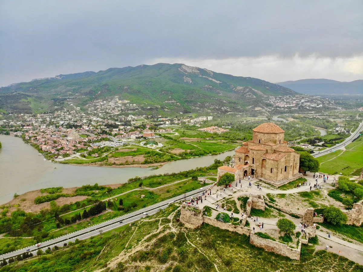
The Jvari Monastery, visible from Mtskheta on the cliff above the confluence, was built in the late 6th and early 7th centuries on the site where St. Nino — the Cappadocian missionary who brought Christianity to Georgia in 337 AD — is said to have raised a wooden cross after her arrival in Kartli. It's one of the earliest surviving examples of the Georgian cross-in-square plan that became the defining form of Georgian ecclesiastical design for the following millennium, and its proportions and spatial organization have influenced Caucasian religious architecture for fourteen hundred years. The view from the Jvari terrace across the confluence to Mtskheta below — Svetitskhoveli visible in the town, the Mtkvari and Aragvi meeting in the foreground — is one of the most celebrated panoramas in Georgia. It's the setting of "Mtsyri," the well-known 1840 narrative poem by the Russian Romantic poet Mikhail Lermontov, written about a young novice at the Mtskheta monastery during Lermontov's time in the Caucasus. Mtskheta and its surrounding monuments were inscribed as a UNESCO World Heritage Site in 1994.
The Georgian Military Highway
The Georgian Military Highway — the main road connecting Tbilisi with the Russian border at the Kazbegi crossing — is both a practical transport route and one of the most scenic drives in the Caucasus. It follows the Aragvi valley north from the Mtskheta junction, climbing through landscapes that change character as the altitude rises and the valley narrows.
The lower section passes through the Mtskheta valley and into the Aragvi gorge above the confluence, forested slopes rising on both sides and the river running fast and green below. The Zhinvali Reservoir, created in the 1980s by a dam on the Aragvi, fills the valley for several kilometers in a striking blue-green — deep and still in calm weather, reflecting the hills above. At its southern end, on a promontory preserved above the waterline when the dam was completed, stands the Ananuri Fortress, one of the most photographed sites in Georgia. The fortress was the seat of the Aragvi eristavni — the feudal dynasty that controlled the Aragvi valley — from the 16th century until their defeat by the Kartlian king Vakhtang VI in 1739. The complex holds two churches within its walls, the larger preserving well-kept frescoes, and the combination of medieval stone architecture, the turquoise reservoir below, and the forested hills above has become one of the defining images of Georgian travel.
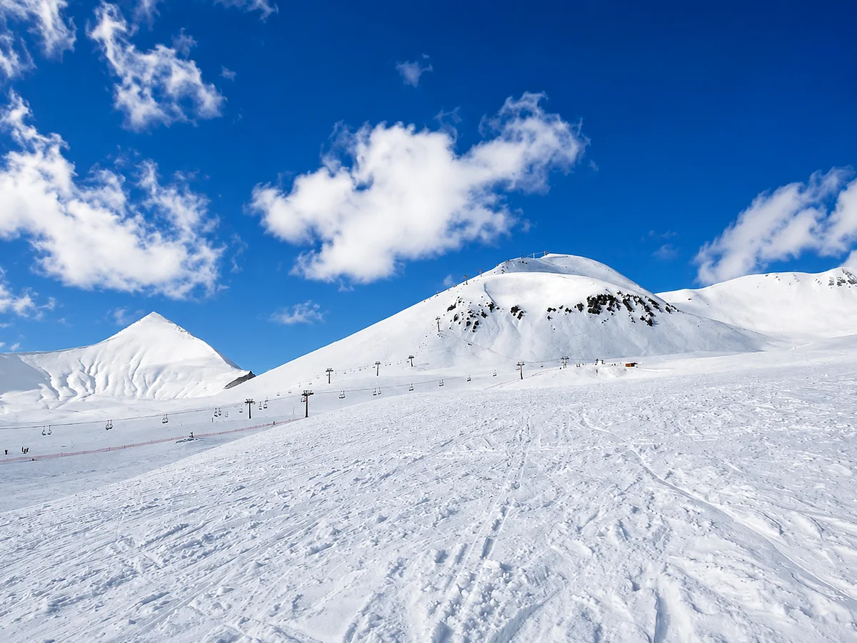
Above Ananuri the road climbs more steeply, the valley narrowing and the vegetation thinning with elevation. The Gudauri ski resort appears at around 2,200 meters, its hotels and lifts on the open slopes above the road. The Jvari Pass, at 2,379 meters, is the highway's highest point and the watershed between the Aragvi and Terek systems. A Soviet-era circular mosaic monument — the Russia-Georgia Friendship Monument, built in 1983 to mark the 200th anniversary of the Treaty of Georgievsk, by which Kartli-Kakheti placed itself under Russian protection — stands at the pass with panoramic views north and south. The descent into the Terek valley is rapid and dramatic, the road dropping through tight switchbacks as the valley opens and Mount Kazbek appears on the eastern horizon.
The highway continues north through the Terek valley to Stepantsminda, then into the Dariali Gorge, where the river forces through the main Caucasus ridge in a canyon of vertical rock walls, and finally to the Larsi crossing with Russia. The gorge section — walls rising hundreds of meters above the road, the river compressed into a narrow channel below — is among the most dramatic passages of any road in the South Caucasus. (The crossing itself is covered in detail in the Kazbegi/Upper Lars border guide in this series.)
Ananuri
Ananuri deserves more than a passing mention as a photo stop. The fortress complex is a genuinely significant monument whose setting above the reservoir has made it ubiquitous in Georgia travel imagery, but whose architecture rewards an hour of real attention rather than a ten-minute stop. The larger of its two churches, the Church of the Assumption (1689), has an exterior of carved relief ornament of considerable quality — the vine-scroll patterns and figurative scenes on the facade are among the finer examples of late-medieval Georgian decorative sculpture. The smaller church is older and simpler, and the defensive towers and walls give a clear sense of the scale and organization of a 17th-century Georgian feudal fortification. The views from the upper walls across the reservoir are excellent in clear weather.
Gudauri and Kazbegi
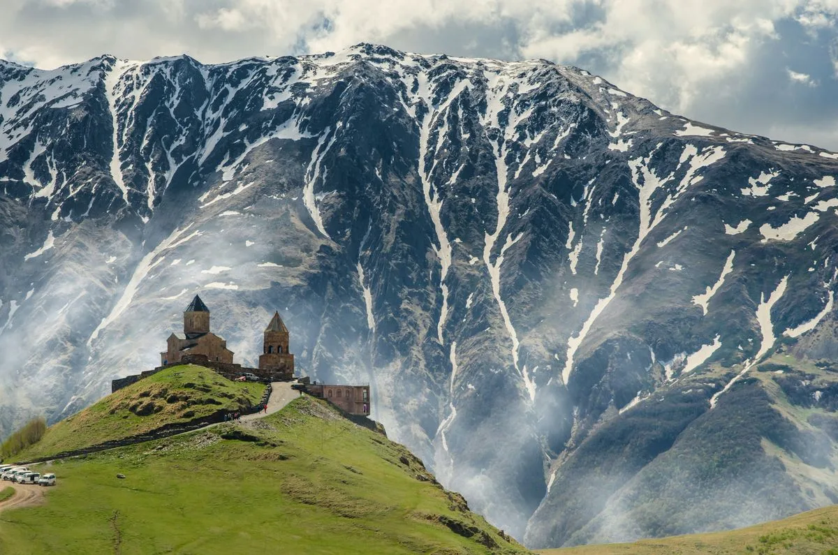
Both Gudauri and Stepantsminda have their own detailed guides in this series. In the regional context, they're the two principal destinations of the mountain zone — Gudauri as Georgia's main high-altitude ski resort and primary winter-sports destination, Stepantsminda as the base for the high Caucasus landscape around Mount Kazbek and the Gergeti Trinity Church. The two are complementary stops on the same road and are frequently combined, using one as a base for a night or two before continuing to the other.
The broader Kazbegi district holds more than Stepantsminda itself — the Truso valley to the west with its mineral springs and medieval ruins, the Dariali Gorge to the north, the Sno valley with its traditional tower villages to the south — and it rewards several days for travelers with time to move beyond the Gergeti church itinerary most visitors follow.
Khevsureti and Pshavi
The eastern part of Mtskheta-Mtianeti, away from the Georgian Military Highway, takes in the remote highland districts of Khevsureti and Pshavi, high mountain terrain reached by secondary roads branching east from the main corridor. Khevsureti in particular has a remarkable cultural distinctiveness — the Khevsurs, the traditional inhabitants, maintained a way of life that preserved pre-Christian ritual elements alongside Orthodox Christianity in an unusual syncretic blend, and their traditional architecture, with its characteristic stone tower-villages and fortified compounds, survives in part in the more remote upper-valley settlements.
The Khevsureti roads are rough, the distances long by Georgian standards, and access to the higher settlements is seasonal — Shatili, the dramatic main Khevsureti village of connected stone towers on a steep slope above a river gorge, is reachable from late spring through early autumn. The effort to reach these areas is considerable relative to the easily accessible parts of the region, but the reward — a landscape and community that feel genuinely remote from the rest of Georgia — matches it for travelers seeking the region's least-visited corners.
Getting there and around
The Georgian Military Highway is the region's main axis, and the access it provides is one of Mtskheta-Mtianeti's greatest practical advantages. Mtskheta is about 20 minutes from Tbilisi by road. Ananuri is roughly 70 kilometers from Tbilisi, under an hour in normal traffic. Gudauri is 120 kilometers, two to two and a half hours. Stepantsminda is 150 kilometers, about three hours. Marshrutkas run from Tbilisi's Didube station to Stepantsminda with reasonable frequency through the day, stopping at Gudauri and passing Ananuri. For Mtskheta, frequent marshrutkas run from Didube and from the Mtskheta junction on the main highway. The Jvari Monastery needs a taxi from Mtskheta town or a car, as it sits on a cliff above the town with no regular public transport. The secondary roads into Khevsureti and Pshavi require a vehicle with good ground clearance and shouldn't be attempted in poor weather without local knowledge.
When to visit
The region is rewarding in all four seasons, though the best conditions vary by zone and by what you're after. Spring (April–June) is excellent for Mtskheta and the lower valley — mild temperatures, green hillsides, and comfortable conditions for the religious and archaeological sites, with the highway fully open and the Aragvi valley at its most lush. Summer is the main season for hiking and trekking in the Kazbegi and Khevsureti areas, with July and August the most reliably stable for high-terrain weather. Autumn (September–October) brings the best light and visibility of the year to the mountain zone — clear air, autumn color in the lower forests, and sharply reduced crowds at the Gergeti church make October one of the finest months in the Kazbegi area. Winter brings the ski season to Gudauri from December through March, and the snow-covered Terek valley and the mountain backdrop behind Stepantsminda take on a particular drama in the cold months, though the road can be affected by snowfall and the Jvari Pass occasionally closes after heavy precipitation.
Caucasus Travel FAQ
It's the region directly north of Tbilisi, running from the ancient capital of Mtskheta up the Georgian Military Highway to the high Caucasus and the Russian border. It's known for Mtskheta's UNESCO monuments (Svetitskhoveli and Jvari), the Military Highway itself, the Ananuri fortress, and the mountain destinations of Gudauri and Kazbegi/Stepantsminda.
It's the historic road from Tbilisi north to the Russian border at the Kazbegi (Upper Lars) crossing, following the Aragvi and Terek valleys over the 2,379-meter Jvari Pass. It's one of the great scenic drives of the Caucasus, passing the Zhinvali Reservoir, Ananuri fortress, Gudauri ski resort, and the Russia-Georgia Friendship Monument before reaching the dramatic Dariali Gorge.
Mtskheta was the capital of the ancient Kingdom of Kartli for around a thousand years and remains the spiritual center of the Georgian Orthodox Church. Its Svetitskhoveli Cathedral (built 1010–1029) is said to hold the burial place of Christ's robe, making it one of the most sacred sites in Georgian Orthodoxy, and it and the nearby Jvari Monastery are UNESCO World Heritage Sites.
Yes — more than a quick photo. The fortress above the turquoise Zhinvali Reservoir is a genuine 17th-century complex with two churches, the larger (1689) carrying fine carved stone ornament, plus defensive towers and walls worth an hour. The setting is one of the most photographed in Georgia, and the views from the walls are excellent in clear weather.
By the Georgian Military Highway: Stepantsminda (Kazbegi) is about 150 km and three hours north of Tbilisi. Marshrutkas run from Tbilisi's Didube station through the day, stopping at Gudauri and passing Ananuri; a car or private transfer gives more flexibility for stopping at the sights along the way. The road can be affected by snow in winter, and the Jvari Pass occasionally closes after heavy snowfall.